Note: I'm still computerless at home, so I'll update this post with my photos later.
On Saturday, June 27, Phil and I took a trip up to Leadville to get in a training ride at altitude and check out the course conditions. With the heavy rains we have been having, I was a little worried about erosion gullys on the descent from Sugarloaf and the Powerline.
We parked in town and rode our bikes from the start at 6th & Harrison. I forgot how fast and fun the first 3 miles are – a sweet pavement downhill. On race day I guess I don't pay much attention to that because I'm trying not to crash and trying not to freeze to death.
Once we turned off onto the dirt all my concerns about the trail condition were alleviated.
The Leadville course is generally sandy, except where it is really rocky (thus my preference for a full suspension bike, even though the hardcore racers insist a hardtail is the only way to go on race day – they are tougher, and generally younger than me . . . just wait . . . they will see the benefits of plush over fast at some point). The rain has made the sand smooth and hard packed - perfect riding conditions.
The St Kevin's climb is still damn steep. I didn't have to dab or walk any part of it, but my heart was pounding in my ears and I was gasping for breath. There simply isn't enough oxygen in the air near Leadville. It was good to be reminded of that, and we'll be spending as much time riding at altitude as we can in the coming weeks.
The pavement section on Turquoise Lake Road between St Kevin's and Sugarloaf is in pretty bad shape. The road crews have been out patching the bigger sections of frost heave damage, but the patches are rough and sometimes have loose gravel/asphalt scattered around, so one goes fast at her/his own peril.
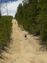
The climb up Sugarloaf is in fantastic condition – I don't recall ever seeing it this smooth. Sure, there are lots of loose sharp rocks, but there is a fairly obvious "good line" the whole way. The descent, however, is sketchy. The rain and erosion have loosened lots of rocks. With no one else on the trail it is easy to pick a good line, but race day will be another story entirely.
Hopefully I'll get two or three more looks before the race so I can get a bit more comfortable. My weakness is descending – I climb like a Billy goat and descend like a girly girl. Sad, but true. All the people I pass easily during the climbs bomb by me like I'm standing still on the downhill sections.
Dammit. I need to work on that.
The Powerline is . . . well, it's the Powerline.
Steep as hell, rutted, sandy and kind of scary. The rain has packed the sandy parts, so that is good, but it has also created some 3 and 4 foot gullys that can eat you up and spit you out like a broken rag doll. Constant vigilance is required. I dabbed once, but otherwise made it down with no problems and without the dry-mouthed terror it use to inspire in me – hey, that's progress!
The creek at the bottom of the Powerline is not running nearly as high and fast as I expected. Using the ever-so-small and unstable plank, you can get across without soaking your feet.
We rode over to the Fish Hatchery, then returned to Leadville via County Road 5, County Road 9 and the Boulevard. Again, I was pleasantly surprised. I expected a mud pit down by the railroad tracks, but it was mostly dry and completely rideable.
It was good to ride the Boulevard – it is always good to remind myself how long that section is. You know – your bike computer shows 100 miles, and you are ready to be done. It is a 2.5 mile mind f*ck.
Remember that on race day, and just keep spinning – you'll be done soon.
July 3, 2009
We went back to Leadville and rode the Powerline section in the other direction. We again parked in town, rode on the pavement out to the Fish Hatchery, then headed up the Powerline.
Ugh. I can only ride about the first half mile, then it's off the bike to push up the rest of the grade (maybe another half mile). Once at the top of the Powerline, I was able to ride all of Sugarloaf with only 3 dabs, I think. Most of those were caused by simple daydreaming. If you aren't fully present and picking out the best line, you'll end up getting into loose rocky crap that can derail your efforts quickly.
A quick – and very rough - ride down to Turquoise Lake Road and then the dreaded slog on the pavement back to St Kevin's.
The ride got interesting here . . .
Phil was just ahead of me. Going into one of the sharp, steep, climbs he waited a little too long to shift, and threw his chain. He told me it was fine, no chain suck, and he'd be right behind me, so I kept riding.
When I got to the top on the final descent off of St Kevin's I waited for him, expecting to see him within minutes. He didn't show up. After about 5 minutes I turned around and rode back down the trail looking for him – afraid that he had a mechanical problem, or perhaps had crashed on a descent while chasing after me.
No Phil.
I rode all the way back to the pavement and didn't see him anywhere. I called him, but no answer on his cell phone – no surprise – I figured he didn't have a signal out in the boonies.
So then I rode all the way to the bottom of St Kevin's, thinking maybe he had flanked me by riding back to the pavement due to a mechanical problem.
Still no Phil – and no answer on his phone.
As I stood at the intersection trying to figure out weather to head back to the car or instead go searching along Turquoise Lake Road, he called.
He had been chasing me and was also thinking about work and chickens (to be explained at a later date . . .) and missed a turn off St Kevin's near the green Forest Service gate. Instead of going down and across the road, he turned uphill and started climbing . . . and climbing . . . and climbing. He finally realized he'd made a mistake, but wasn't sure where.
It took him a while to get back on track, but eventually – after more climbing than he really needed to do, he did get sorted out.
All is well that ends with no broken bones, right?
We once again beat the deluge – lucky for us. It rained so hard it was blowing manhole covers off! Nice to be inside watching rather than scrambling for cover when that kind of weather moves through.
Monday, July 6, 2009
Subscribe to:
Post Comments (Atom)

great info on the race course. Have you made it over to Columbine yet? I heard that they have done some "roadwork" and that it is REALLY soft (yikes).
ReplyDeleteI just stumbled upon your blog - great blog!
We're doing Larame and Leadville too! Good luck!
Thanks for the comment, Dan. We haven't made it up to Columbine yet. We'll probably ride it on the 19th or the weekend of the 25th. We can only hope all this rain may be packing it down.
ReplyDeleteWe understand they are building a new section of trail to bypass AT&T hill (it has several other colorful names, too) on the 18th of July, but we'll be racing the Mt Evans Hill Climb that day.
Good luck to you as well!